
GREENER JOURNAL OF ENVIRONMENTAL MANAGEMENT AND PUBLIC SAFETY
ISSN: 2354-2276
Submitted: 10/02/2016 Accepted: 20/02/2016 Published:07/04/2016
Research Article (DOI: http://doi.org/10.15580/GJEMPS.2016.2.021016035)
Production of Street Guide of Ijero Ekiti Using
Remote Sensing and GIS Technology
1Fasote O, 1Kolawole I, 1Adewoyin JE, 2Mohammed SO,
1Alaga TA, 2Halilu SA, 1Muibi KH
1Cooperative Information Network, Obafemi Awolowo University, Ile Ife Nigeria
2 National Space Research and Development Agency, Abuja, Nigeria
*Corresponding Author’s Email: bfasote@ yahoo.com
ABSTRACT
The use of remote sensing data and geographic information system technique especially with high spatial resolution satellite imagery has great capabilities for mapping and map revision. These techniques have been used in various times and at different stages to study characteristics of Earth features, monitor natural and physical phenomena and also produce street maps of different places.
The aim of this study is to demonstrate how street guide maps can be produced from remotely sensed data using GIS and Remote Sensing techniques. Google Earth image of 2014 with resolution of 0.6m and GPS points were the major source of data used to update and produce the Street Map of Ijero Ekiti, a town in western Nigeria.
The methodology adopted for the research is an integrated and conceptualized approach consisting of digital image processing and cartographic procedures. Data capture was by scanning and digitizing of google earth image while field work was carried out for the purpose of groundtruthing, annotation and for collection of coordinates of selected control points. The acquired data was processed using Arc GIS 10.3. During groundtruthing, identified street names were collated and placed on the map with additional information obtained from the existing street guide and also from people of the community. On close interpretation of the imageries, it was discovered that streets in Ijero- Ekiti have increased in number and many of those streets have not been registered.
Keywords: Remote Sensing, Street Guide, Digitizing, Groundtruthing.
1.0 INTRODUCTION
From the earliest civilization, maps have been used to portray information about the earth’s surface Navigators, land surveyors, town planners, military architects, etc. use maps to show spatial distribution of important geographic features (Bashir, I.B., 2001). Street guides are produced to show road information that is current especially to visitors and researchers (Ogunleye et al 2007). Street guides are not only important for aiding navigation within the city, but are also useful in planning enumeration areas by demographers, and are equally useful to tourists, salesmen, firemen, police, security agents, tax collectors, postal services etc. and also serve as base for land use classification mapping and town planning.
In Nigeria, movement of goods and services, social and economic development of the country are dependent on good road network as road is the major means for transportation (Olaore 2004). As observed by (Igbokwe 2011), very few rail lines exist in the country and are mostly unreliable.
Besides, high and accelerating rate of urban changes and township area extensions, that leads to construction of new roads particularly in a developing country such as Nigeria, calls for an efficient and fast technique that will meet mapping standards and accuracy for mapping and regular updating of these changes. In the past, the processes used for mapping and revision of maps had been the classical land surveying method (Ezra et al 2007). Later in the nineteen century, aerial photographs were used to extract data for producing and revising topographic maps. These methods proved to be time consuming and inefficient for large study areas and limited in the ability to conduct frequent updating and revision (Ndukwe 2001). Fortunately, remote sensing, a fast means of acquiring data about the environment without physical contact with the features has made significant advances over the past twenty years in providing cost effective data for mapping.
Since data from satellites becomes available for commercial use, they have served as a useful means of monitoring our environment and the state of our road networks and also provides the tool to constantly map these road networks and even plan for new ones. The availability of the new generation satellite imageries have opened a new era and signaled promising futures for producing and updating digital maps. Satellite remote systems provide a synoptic view of large portions of the earth surface as an entity rather than in small bits. These images allow a view and the analysis of different features of the environment (and even road network) on regional and global scale.
GIS and remote sensing in map production allow for the combination of data from different sources as well as the interpretation, manipulation, management, analysis and accurate presentation of map information. This approach also gives optimal benefits as the advantages of both technologies are combined in the mapping process. This however has been ascertained by many scholars and researchers. For instance, Abbas et al concluded that street mapping using remote sensing data and GIS technique is less tasking compared to the traditional map making and is also cost effective and time saving. They posited that remotely sensed data provides repetitive, synoptic view and accurate information that can be used to obtain up-to-date maps. Nnam et al. also demonstrated that the use of satellite imagery together with computer hardware and software technology (GIS) in street map production have tremendously improved both the speed and quality of map making as well as increase the precision, accuracy, quality and productivity. This has enhanced the capability / capacity of producing high precision and quality maps (street map) within a reasonable time frame and at a greatly reduced production cost.
1.1 Aim and Objective of the study
The aim of the project is to develop street map of road network in Ijero Ekiti, Ekiti State, Nigeria.
The objectives of the study are to digitize all the existing roads in the town, to identify the roads and label them on the map and to show the road network of Ijero Ekiti on the map for easy navigation.
1.1. The study area
The study area is Ijero Ekiti, the headquarters of Ijero Local Government which was created in 1976. It is situated in the North-Western part of Ekiti State. Its location is between latitudes 7°51’54.15’’N and 7°49’22.10’’N and longitude 5° 02’ 17.58’’E and 5°5’25.37’’ E respectively. Other neighbourhood towns are: Ikoro, Ipoti, Iloro, OdoOwa, Ijurin, Ara, Epe, Araromi, Oke-oro, Iroko, Ayegunle, Temidire and Ilukuno.
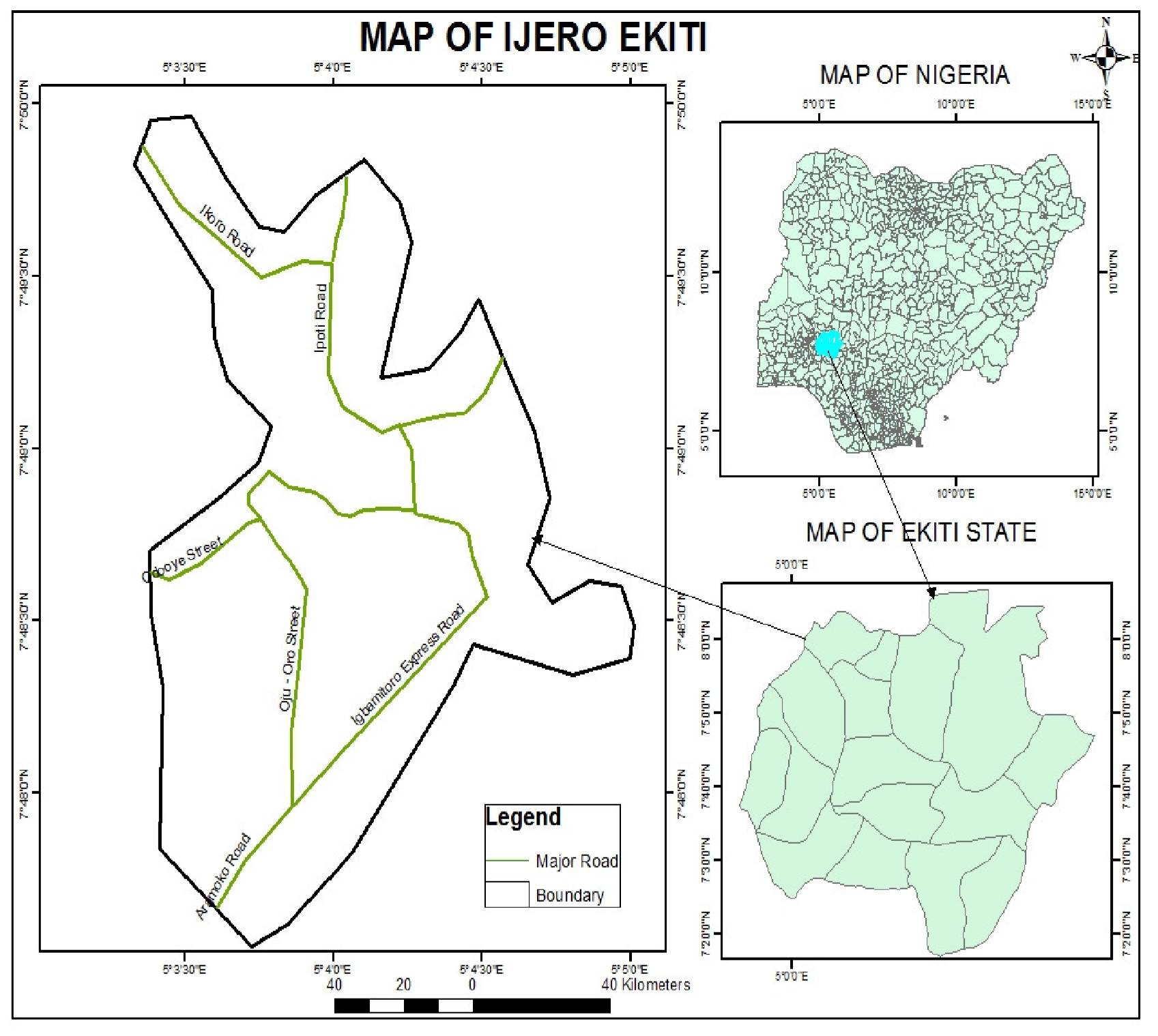
Fig 1: Map of the Study Area
1.2 Data acquisition and data source
To produce a street guide that does not exist or that needs updating, primary data acquisition method is preferable, whereby new data are obtained by ground surveying or remote sensing surveying. This therefore necessitated the acquisition of Geo-Eye satellite Imagery 2014 with resolution of 0.6m to serve as the primary source of data and other data for the project was derived from field work.
2.0 METHODOLOGY
The mapping of urban road by remote sensing and GIS techniques can be accomplished by either automatically extracting the road network from remote sensing imagery using different approaches or by digitizing the imagery and applying normal cartographic procedures. The methodology adopted for this research involves:
Data analysis
Data Acquisition ![]() Data Input
Data Input ![]() Geo-referencing
Geo-referencing ![]() Digitization of Road
Digitization of Road
Network ![]() Field Work
Field Work ![]() Map Production
Map Production
Data Acquisition: Data acquisition is the first step in the execution of any mapping project after the preliminary stage of planning. It is a very important aspect of GIS as the type of data obtained and the accuracy of the data determines the output of the whole process. In this work, this was taken into consideration.
Data Input: Data encoding for this research involves geo-referencing, digitizing and layering the final map product.
Geo-referencing: The longitude and latitude coordinate of points depicted with GPS will be transformed to Universal Transverse Mercator (UTM) coordinate system. The value will use as tie points to geo-reference Ijero Ekiti imagery and also to create map boundary.
Digitizing Process: Major roads, minor roads, access roads and footpaths were identified and traced in Ijero Ekiti town. Data capture refers to the digitizing process by which new data required to produce or revise a map is transformed into digital format for storage and further processing where necessary. Upon registration, the different features found on the scanned streets guide were captured using the heads up digitizing method of raster data vectorization in layers. The different layers identified were roads, drainage, facilities and footpath.
Field Work: Ground truthing would be embarked upon to verify some of the information interpreted during data capture. Collection of road names using one-on-one interview and street delineation.
Map Production: All decisions on the basic elements of a map are reached at this stage, such decisions are on the symbolization, colour concept, visual perception, sizes, legend and scale. They are important because they are the components of the map, which it must bear, and the map is viewed as whole composed of these components.
3.0 RESULTS AND DISCUSSION
The study was based on the digitizing of 2014 Geo eye satellite imagery of Ijero Ekiti coupled with data gotten from ground truthing.
In the study area, related features identified on the image are Ogburu and Iregun water channel, major roads, minor roads, foot path and one roundabount located in the main market, close to the palace.
On close interpretation of the imageries and groundtruthing process, it was observed that streets in Ijero- Ekiti have increased in quantity and many of those streets have not been registered while some does not have name.
The results of the GIS analysis show that major roads in the study area accounted for 19.3% while the minor roads are 80.7%. All the roads in the study area were 82.
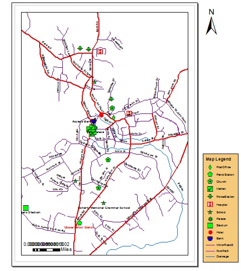
Fig 4: Road Network Map of Ijero - Ekiti
4.0 CONCLUSION
It is worthwhile to state from this study, that street mapping using remotely sensed data and GIS technique is very important and less tasking compared to the traditional manual map making. It is also cost effective and time saving in view of the size of the study area.
From this study therefore, it can be concluded that:
• Remotely sensed data and GIS provide a reliable base for mapping streets especially when quality-high resolution satellite imageries are used.
• Updating of maps is easier and less costly by using remote sensing data in a GIS environment because it only entails updating the digital mapping system data base.
5. RECOMMENDATION
The full potential of remote sensing and GIS can be realized by integrating remotely sensed data in a geographic information system environment. The following recommendations are therefore made;
• The use of remotely sensed data should be adopted for mapping purpose
• Revision of all categories of maps should be embarked upon as often as possible
• Quality – high resolution satellite imageries should be made available at relatively low – cost.
• Relevant government agencies should endeavour to keep database of street information and names approved by them in order to arrest ambiguity in the choice of which name a road bears.
REFERENCES
Bashir, I.B., 2001. The use of remotely sensed data in assessing land degradation. An M.Sc. Thesis of the Federal University of Technology, Minna.
Ezra, P.H. and L. Kantiok, 2007. The relevance of maps in the control of urban slums. Proceedings of the 29thAnnual Conference of NCA, Kaduna.
Ndukwe, K.N., 1997. Principles of environmental remote sensing and photo Interpretation, New concept publishers, Enugu, Nigeria.
Ndukwe, K.N., 2001. Digital technology in surveying and mapping. RhyceKerex Publishers, Enugu, Nigeria.
Ogunleye, A.Y. and A.A. Obiniyi, 2007. Mapping and cartography. Proceedings of the 29th Annualconference of NCA, 2007, Kaduna.
Olaore, L.Y., 2004. An integrated use of spot X5 and GPS data for updating topographic maps in a GISenvironment. M.Sc. Thesis of the Federal University of Technology Minna.
Cite this Article: Fasote O, Kolawole I, Adewoyin JE, Mohammed SO, Alaga TA, Halilu SA, Muibi KH (2016). Production of Street Guide of Ijero Ekiti Using Remote Sensing and GIS Technology. Greener Journal of Environmental Management and Public Safety, 5(2): 033-040, http://doi.org/10.15580/GJEMPS.2016.2.021016035