This study
assessed the impact of Urbanization on Agricultural farm land in Akure South Local Government Area of Ondo
State. The data collected were populated figures and land use for three
Epochs (2002, 2012 and 2022). The satellite images were downloaded from the
Google Earth. In the analysis, cross change detection analysis and overlay
analysis using ArcGIS 10.8 was performed to detect where land use change has
occurred and which type of land use agricultural land has transformed too.
The GIS analysis revealed that there is an increase in settlement and a
decrease in Agricultural land from 2002 – 2022.Results reveal that urbanization has
significant effects on Agricultural land in the study area and these effects
include, decreasing agricultural land, decreasing in faring activities,
decreasing in farm size. All this is as results of increasing settlement and
built up area. If the growth in the population of Akure
South LGA continues, unchecked, agricultural land will be significantly
depleted in the future. The study recommendation that there should be
effective.
Law
and policy to control population growth sustainably to minimize the negative
impact of urbanization in the study area. Also urban agriculture should be
encouraged to sustain the food supply, to prevent food scarcity and secure
food for future consumption.
Keywords: Urbanization,
Agricultural Farm Land, Food Scarcity and Effect.
INTRODUCTION
Urbanization is the process of people concentrating in
cities, driven by natural population growth, rural-urban migration, and
reclassification of rural areas. This urban growth is
influenced by push factors like rural poverty and pull factors such as
city allure. In many developing regions, rural-urban migration is exacerbated
by limited agricultural land and food insecurity.
Nigeria faces food security challenges due to low
agricultural productivity, exacerbated by issues like herdsmen menace and
insecurity in rural settlements. The global concern over producing enough food
for a growing population has persisted for generations. Food insecurity
elimination is a significant focus of the Sustainable Development Goals,
addressing pressing needs in developing countries.
Enhancing agriculture is vital to empower smallholders
and alleviate poverty. Land use and degradation play a central role in
agricultural productivity discussions. Food, as a fundamental human need,
necessitates addressing land degradation, which is a pressing issue in
developing nations Abah. andPetja, (2015). Maintaining healthy land ecosystems is crucial for
global food security and population growth.
Sustainable development, as emphasized by the Food and
Agricultural Organization (FAO), aims to meet current and future generations'
needs while ensuring profitability, environmental health, and social equity.
Sustainability is the foundation of agricultural development, as per McKenzie
et al. (2015).
Food security is a universal human right, ensuring
everyone's access to adequate food. Achieving this goal is paramount, as per
the FAO. To address the challenges of urbanization, population growth, and
agriculture, a holistic approach is essential, emphasizing sustainability and
food security.
The rural-to-urban migration, a global concern,
particularly in developing nations like Nigeria, poses a significant threat to
food security. Regular assessments of the impact of urbanization on
agricultural land use are essential for informed policy decisions. This study
focuses on urbanization's effect on agricultural land use in relation to
Sustainable Development Goal (SDG) 2. It analyzes
trends in agricultural land from 1990 to 2020 to gauge urbanization's impact on
land sustainability.
Urban expansion significantly affects physical
development, with numerous studies on this issue globally, particularly in
developing countries like Nigeria. Efforts to enhance food security,
agricultural productivity, land sustainability, and agribusiness markets are
prioritized by governments and stakeholders, but challenges persist, especially
for smallholder farmers facing food insecurity and socioeconomic hardships Owolabi, (2018).
To plan for the future, understanding how human needs
transform land use is crucial. Urban changes can be predicted by studying past
trends and projecting future developments.
The incessant migration of rural populace to
urban areas has imposed a serious concern globally, especially in developing
countries like Nigeria due to its accompanying food security threat. Therefore,
there is a need to map and evaluate the effect of urbanization on agricultural
land used in relation to farming challenges periodically in order to be
well-informed policy statements in tackling food security. This study evaluates
the effect of urbanization on agricultural land use in relationship to (SDGs) goal
no 2. This study will help to carry out trends, what have happen over the years
to agricultural land, from 1990 to 2020, with the view of analysing the effect
of urbanization on the sustainability of agricultural land. The antecedent
impact on the physical development constitutes a major concern. Although there
have been studies on the rapid urbanization and urban sprawl of cities in the
developing countries and in Nigeria, Globally, approaches for providing
sustainable food security for smallholder households have increasingly gained
priority in agriculture planning and policy. In addressing food insecurity,
governments and relevant stakeholders continue to formulate and implement
various agricultural and development planning policies aimed at improving food
security, agriculture productivity, land use sustainability, and agribusiness
markets Akinluyi et al., (2020).Despite these
interventions, higher concentrations of food insecurity and socioeconomic
deprivation have been recorded in LMICs, especially among poor smallholder
farmers. Collier et al. (2009) He observes that human needs transform the
land to different activities and that the quantifiable information of these
dominant activities is necessary to develop future planning. Urban changes can
be modelled through the observation of the past and projection to the future.
Aim
The aim of this study is to investigate the
effects of urbanization on s agricultural land in Akure
South Local Government, Ondo State.
Objectives
The specific objectives are to:
•Determine the change in the land classes in
the study area between 2002 sand 2022.
•Assess the
of urbanization growth on agricultural land in the study area.
•Show how population in the study area has
grown between 2002 and 2022
Study Area
The area of study is Akure
South Local Government Area of Ondo State. It is
located between longitude 5˚4’28.83” E and 5̊ 21’2.30” E, and
Latitude 7˚5’34.93” N and 7˚21’35.1” N. It has an area of about 325.5
Square Kilometer, with a population of 353,211 at the
Ajomale (2007).Akure is a medium-
sized urban Centre and became the provincial headquarter of Ondo
State. It is located within the tropical rain forest region of Nigeria. The
land mass of Akure South is about 250 metres above
sea level. The major occupation in the area is agriculture, rearing of animals
and trading is a common economic activity among the women.
Figure 1:
Study area map
METHODOLOGY
Data Collection and Preparation
This research used both primary and secondary data. The
primary data were gotten from the Google earth pro software and the population
data was acquired from the State National Population Commission.
The Landsat imageries for three decade with
the interval of ten years were downloaded, respectively, obtained from USGS
Website. 2002, 2012 and 2022. The different Landsat
bands were combined to bands in Arc Map to form a false colour composite image.
In Erdas imagine, pixels representing vegetation,
built-up, area rock outcrop, water body and farmland were identified and
selected from the image as training sample. Their signature files were also generated
and saved.
Data Analysis
The population data was imported into Microsoft Excel
software, Bar chart was generated to show the population growth between 2002
and 2022
The 2002, 2012 and 2023 images of the study
area were classified respectively into four classes such as; Built- up,
Vegetation, Farmland and Rock outcrop.The land use/ land cover classes data were imported into Microsoft Excel
software, where bar charts were generated to show the land use/ land cover in
hectares and comparative changes between 2002 and 2022.
The layer of the built-up extracted from the
2002, 2012 and 2022 images respectively were overlaid to show the extent of the
population increase in the study area. Farmland of the 2002, 2012 and 2022
respectively, were carved out from the classified image of the study area and
overlaid with the built-up layer to show the area covered by
agricultural land in 2002 2012 and 2022 areas that have been encroached
by built-up.
The farmland data was further imported into
Microsoft Excel software, bar chart was generated to show the farmland decrease
in hectare between 2002 and 2022.
Figure 2:Research work
flow diagram.
RESULTS AND
DISCUSSION
Results
The Population Data Analysis
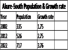
Table 1: Showing the population and the growth rate of
the study area.
The bar charts showing the population and growth rate of
the study area between 2002 and 2022.
Figure 3: shows the population growths of the
study area from 2002 to 2022.
Figure 4: showing the growth rate of the
study area from 2002 to 2022.
Image Classification Results
The classification images showed the land use
land cover map of the study area from 2002 to 2022.
Figure 5: Land Use Land Cover Map of Akure South LGA in 2002
Figure 6: Land Cover Classes and their
Respective Area Cover in percentage in 2002
Figure 7: Land Use Land Cover Map of Akure South LGA in 2012.
Figure 8: Land Cover Classes and their
Respective Area Cover in percentage in 2012.
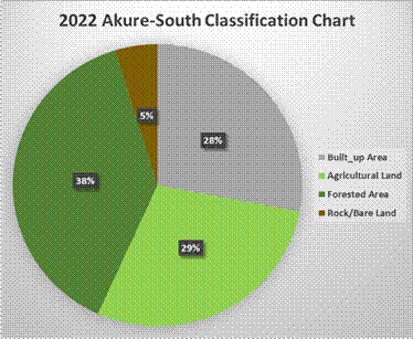
Figure 9: Land Use Land Cover Map of Akure South LGA in 2022.
Figure 10: Land Cover Classes and their Respective
Area Cover in percentage in 2022.
Figure 11: the comparatives changes in land
cover classes between 2002 and 2022.
DISCUSSION
Table 1 above shows the steady increment in the
population growth of the Akure South LGA from 2002 to
2022. Year 2002 has the lowest population while 2022 has the highest population
growth, Figure 3 showing the population growth rate of the study area, in the
year 2002 the growth rate was 335% at 1.75 while in the year 2022 the growth
was 717% at 3.76 rates. Combined with the population data respectively in other
to show the population increase in the study area, in 2002 built up has the
population of 1868.99, 2012 built up has population of 3577.2 and 2022 has the
population of 9198.9 respectively. The increase in population is an evidence of
urbanization in the study area
Figure
4: above shows the land use land cover classified image of the year 2002. From
the classified image of the year 2002, the percentage of the agricultural land
is 36%, while the built-up area was 6%, the forest area covers 55% and the bare
land was 3% respectively. While figure 5 shows the land classes in the year,
while figure 6 shows the percentages they occupies in the change analysis, it
shows that the forest has the highest percentage. Hence the area is slightly
dominated by built up area.
Figure 7 above shows the land use land over
of the year 2012. While figure 8 shows the percentages. In the year 2012, the
Agricultural land decrease from 36% to 24, while the built up area was
increased from 6% to 11%. On the other hand the bare land also experienced
little increment from 3% to 5%. The forest area also experienced increment from
61% in the year 2002 to 38% in the year 2012. Hence there is urbanization.
Figure 9 above shows the land use land cover
classified image of the year 2022. The built up increased massively due to
encroachment in to the forested land area. While the figure 10 shows the
percentages changes. Built up covers 28%, Agricultural land 29%, forest land
38% and bare land 5%.
Figure 11 above shows the comparative changes
in the land use land cover classes in hectares from 2002 and 2022. The bar
chart revealed that the agricultural land cover in the study area decrease from
2002 to 2022, this is due to the advent of urbanization in the study area as
some forested and agricultural land has been turned to either settlement or
recreation centres. The figure 4.10 also revealed that the built up area kept
increasing from 2002 to 2022, this has been attributed to increase in
population over the study area which as a result led to urbanization.
Filani, (2011) said agricultural is the life wire of many human
being, thus; the major operation of people of Akure
South LGA has been identified to be agriculture. The area covered by land kept
decreasing from 2002 to 2012 until 2022 while it has lost to 162658 to hectares
of land to majorly built up as a result of increase in
population in the study area. The area covered by forest decrease rapidly from
2012 to 2022 respectively.
Impacts of Urban Growth
The analysis above has confirmed the advent of
urbanization and how it has affected other land cover types, but here, the
study is focusing on the impacts of the urbanization on the Agricultural land.
As result of declination in the loss of
agricultural farm land, the study orally interviewed some farmers to ask for
the possible reasons why such drastically declination might have occurred. The
following are their reasons;
1Over 90% of
the farmers claimed that urbanization has been one of their major problems as
their farmland has been converted to settlement, thereby causing them to look
for another farmland.
2The farmers
also lamented that with the advent of crude oil in Nigeria, some of the farmers
disengage agricultural activity for white cola jobs in the city. More also
their children don’t see farming as a mean of survival anymore because
theyneed quick money which make them to
abandoned farming and go for minor business in town that will bring them easy
money.
3Furthermore,
the farmers also explain that with the problem ofFulani headsmen.
Encroaching
into their farmer always results into crisis between the farmers and the Fulani
headmen which also affect the production of their farm produce.
CONCLUSION
AND RECOMMENDATION
Conclusion
In conclusion, the results and discussions presented in
Chapter Four shed light on the significant changes that have occurred in the Akure South Local Government Area (LGA) from 2002 to 2022.
These changes are primarily driven by population growth and urbanization, which
have had profound impacts on land use and land cover in the study area.
The population analysis revealed a steady
increase in population from 2002 to 2022, with the year 2022 witnessing the
highest population growth. This population growth is indicative of urbanization
taking place in the region. The growth rate increased from 335% in 2002 to 717%
in 2022, reflecting the rapid pace of urbanization.
The land use and land cover analysis provided
valuable insights into the changing landscape of Akure
South LGA. In 2002, the dominant land cover was forest (55%), while
agricultural land covered 36%. However, by 2022, the built-up area had
significantly expanded, covering 28% of the land, indicating the encroachment
of urban areas into previously forested and agricultural regions. This shift
highlights the urbanization process and its consequences for land use (Fenta,.et al(2017).
The comparative analysis between 2002 and
2022 showed a decrease in agricultural land and a substantial increase in
built-up areas. This transformation can be attributed to the effects of
urbanization, including land conversion for settlement and recreational
purposes. Furthermore, the study revealed that the area covered by forests
decreased rapidly from 2012 to 2022, indicating a loss of valuable natural
resources.
The impacts of urban growth on agricultural
land were also examined, with farmers reporting significant challenges.
Urbanization was identified as a major problem leading to the conversion of
farmland into settlement areas, forcing farmers to seek new land for cultivation.
Additionally, the allure of white-collar jobs in the city and the desire for
quick money among the younger generation has contributed to a decline in
agricultural activities. Conflicts with Fulani herdsmen further exacerbated the
challenges faced by farmers in the region.
In summary, the results and discussions in
this chapter illustrate the transformation of Akure
South LGA over the past two decades. The region has experienced rapid
urbanization, resulting in changes in land use and land cover, and significant
challenges for the agricultural sector. These findings underscore the
importance of sustainable urban planning and the need for policies that balance
urban development with the preservation of agricultural land and natural
resources. The implications of urbanization on agriculture and the livelihoods
of farmers in the region call for targeted interventions to address these
challenges and ensure the long-term well-being of the local population.
Recommendation
The recommendations aim to address
the challenges arising from rapid urbanization and shifting land use in Akure South Local Government Area (LGA) between 2002 and
2022:
Urban Planning and Zoning Policies: Implement effective urban planning and zoning policies to control
urban sprawl, protect agricultural land, and preserve natural resources.
Agricultural Support Programs: Support
farmers by providing alternative land, training, credit access, and market
opportunities to mitigate the impact of urbanization on agriculture.
Environmental Conservation: Launch
conservation efforts like afforestation, reforestation, and sustainable
land management to protect remaining forested areas and natural resources.
Infrastructure Development: Invest in
infrastructure to accommodate urban growth while minimizing agricultural
land conversion, including transportation, housing, and utilities.
Community Engagement: Engage local
communities, including farmers, in decision-making processes for urban
development and land use planning to consider local needs.
Youth Employment Programs: Develop
initiatives to create employment opportunities in agriculture for the
younger generation through training and incentives.
Conflict Resolution: Address
conflicts between farmers and other groups peacefully to promote
coexistence and better land use practices.
Data Monitoring and Analysis:
Continuously monitor population growth, land use changes, and their
impacts to inform policy adjustments.
Education and Awareness: Raise awareness
about the consequences of rapid urbanization to encourage responsible
development and land use practices.
Collaboration: Foster collaboration among
government agencies, NGOs, community groups, and academic institutions to
work on sustainable development initiatives and policy implementation.
These recommendations
aim to strike a balance between urban development and the preservation of
agriculture and natural resources while improving the well-being of the local
population in Akure South LGA.
REFERENCES
Abah, R. and Petja, B. M (2015): An
application of Geographic Information System in mapping flood risk zones in a
north central city in Nigeria, African Journal of
Environmental Science and Technology, 7 (6). 365-371. doi:
10.5897/AJEST12.182
Ajomale, O.,
2007. Country report: ageing in Nigeria–current state, social and economic
implications. Summer newsletter, pp.15-20.
Akinluyi et
al., (2020): Assessment of urban Residential Land use, Challenge and Control in
Oritaobele Housing Estate,
AkureNigeria.March 2020.American journal of Engineering and Applied
Science, 13(3). 390-401 doi:
10.3844/ajeassp.2020.390.401.
Ayele, A.
F., Hiroshi, Y., Nigussie, H., Ashebir,
S. B., Zelalem, H., Mewcha,
A. G. and Getachew, M. (2017): The dynamics of urban
expansion and land use/land cover changes using remote sensing and spatial
metrics: the case of Mekelle City of northern
Ethiopia, International Journal Of Remote
Sensing, 38 (14). 4107–4129.http://dx.doi.org/10.1080/01431161.2017.1317936.
Collier, Paul, AnkeHoeffler, and Dominic Rohner. "Beyond greed and grievance:
feasibility and civil war." oxford Economic papers 61.1 (2009):
1-27.
McKenzie, Grant, et al. "How where is
when? On the regional variability and resolution of geosocial temporal signatures for points of interest."Computers, Environment and Urban Systems 54 (2015): 336-346.
Filani, M.
(2011), “Urbanization and Millennium Development Gold” 50th anniversary
ofUniversity
of Benin.
Owolabi, B. O. (2018). Assessment
of Urban Sprawl Occurrence in Oyo State, Nigeria.International
Journal of Research Studies in Science, Engineering and Technology, 5(1),
23-50.
.
Cite this Article:
Benson, AG; Ehisienmhen, NO; Adewale, ET;
Animasahun-Oladimeji, R; Aribilola, TR; Afiz, RA; Okeke, AI; John, OA; Isa,
I; Imran, BO; Dirisu, KD; Omisore, OO(2023). Effect of Urbanization on Agricultural Farm Land in Akure South
Local Government Area, Ondo State. Greener Journal of Agricultural Sciences, 13(4): 274-283.